")
")
Gunjiin sum
Read in Mongolian
Name(s) of Temple :
Gunjiin sum,
Rinchen Number :
423
Rinchen Name :
Baruunbayangiin khural, bayangiin khural, Gunjiin sum
Type of Monastery/Temple:
Temple
Aimag where the temple is located:
Töv
Sum where the temple is located:
Erdenesum
Sub-district where the temple is located :
Khukh Golyn source, B. Rinchen 423 is marked in Bayanzurkh soum area of Töv
Old Aimag Name :
Tusheet Khan
Old Khoshuu Name :
Darkhan chin vangiin khoshuu
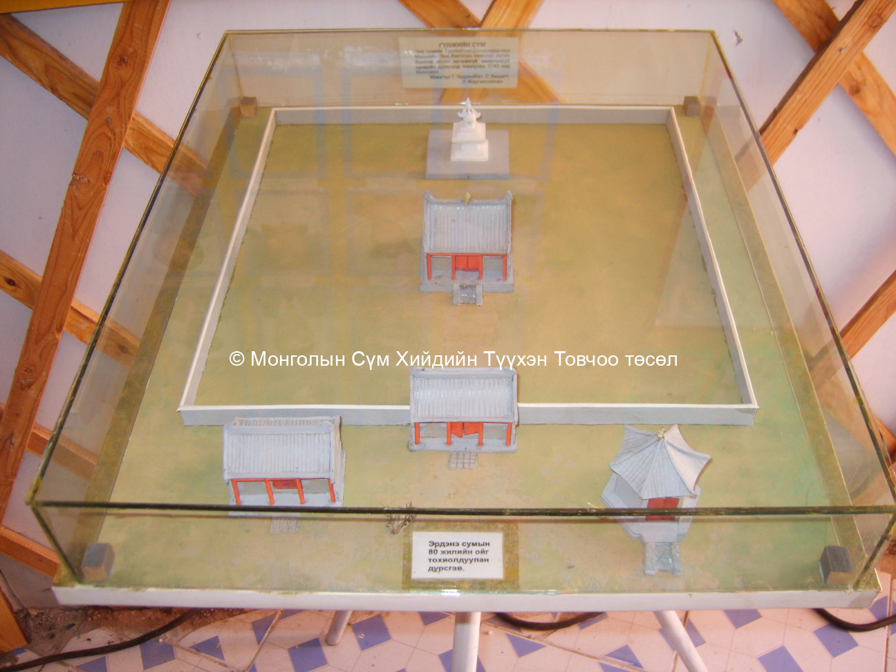
Historical Summary (In Mongolian only):
Төв аймаг Эрдэнэ сум. Гүнжийн сүм Сумын төвөөс хойш 110 орчим км газар Хэнтийн нурууны салбар уул Баян уулын өвөр хормой хөх чулууны голын эхэнд өндөр уулын хөвч модон дунд энэ сүм байдаг.Энэ нь Түшээт хан Чахундоржийн ач хүү Дондовдоржид 1697 онд Манжийн хаан охиноо гэргий болгон өгчээ.Дондовдорж үүнээс 43 жилийн дараа ар Халхын газраа нас барсан Манжийн Энх амгалан хааны охин “Хичээнгүй Амарлингуй” гүнжийн шарьлийн хөшөөг 1740 онд бариулжээ.Гүнжийн сүмийн тууринд 2,5 метр өндөр хэрмэн хашааны туурь, үүний дотор гол сүм, шарьлийн суварга бий.Хэрмэний гадна талд харгалзагчийн байшин, цамхагийн туурь үлджээ.Суварганы дор байсан булшны барилга байгууламж нь 7,5 метр урт 5 метр өргөн, 1,75 метр өндөр бөгөөд дотуураа тоосго өрсөн давхар өрөөтэй байв.Гол сүм нь дөрвөлжин хэлбэртэй 4,2 метр өндөртэй 8 баганатай бөгөөд урдаас хойшоо нэвт гарсан хаалгатай байжээ.Гүнжийн сүм нь 13-р зууны үеийн нэрт хаад хутагт хувилгаадын шарьлийг суваргалан оршуулдаг төв азийн монголчуудын оршуулгын зан үйл 17-р зууны хагсаас хойш шарилтай гүдэнгийн гадуур сүм барьдаг болсон шинэчлэлийг харуулж байна.Уг сүмийг барьсны дараа 19-р зууны сүүлч үе хүртэл мөнх зултай тахилч ламтай сар жилийн дүйцэн өдрүүдээр лам нар очиж хурал хурдаг байжээ. Холбогдох эх сурвалж: 1.Сэдэвчилсэн лавлах “Монгол нутаг дахь түүх соёлын дурсгалт зүйлс” УБ 1999 2.Л.Хэнчяахав “Төв аймаг бага толь” УБ 1993 3.Эрдэнэ сумын өндөр настан ахмад багш Дашдондог гуайтай хийсэн ярилцлагаас 2007.11.10
Description of location :
The ruin of the monastery is situated on the slope of Bayan uul, which is part of Khentii mountain range. The site is at the mouth of the Khukh Chuluunii Valley. The area is rugged with thick forest cover so a cars can only go so far and then one has to travel on horse back or on foot. The area is called Khukh Chuluunii Valley.
GPS coordinates :
North 48° 73’ East 107° 47’
Total site area:
Side1: Side2: Side3: Side4: Side5: Side6:
Revived temple on site :
No
Site status at the time of survey :
As you pass through a thick forest there is a small opening where the temple ruins lie. An ovoo has been created by the visitors and there is a sign saying Gunjiin Sum. It is not clear when the sign was put there.
Date of establishment of the monastery/temple :
1715-1720
Date of closing and destroying the monastery :
Revival of the old monastery/temple:
No
Founder's name and title (if known):
Name and title : Darkhan chin van khoshuu noyon Dondovdorj - Interview Number:
Date of Revival:
Monks in Old Temple :
not clear
not clear
Form Number :
ТӨЭР 045
Survey Team :
Team F